Why and How to Use a Green Emitting LiDAR to Capture Underwater Topologies
LiDAR is widely discussed in 3D automotive sensing, topology mapping, and space exploration circles. The final earth-bound frontier is the development of a tool for exploring underwater topological structures. With such a tool, engineers can survey the Australian barrier reefs, determine lake or pond water depth, detect underwater physical obstructions, and determine water quality.
Engineers call this survey process bathymetry, in which drones are often used to carry the instrumentation. However, the standard infrared (IR) light used in a typical LiDAR system bounces back from the water’s surface. As a result, the IR light from these drones never “sees” what’s underneath.
That’s not to say there is no way for engineers to peer into the water and determine structures beneath the surface. The acoustic Doppler current profiler (ADCP) measures stream flow by transmitting reflected sound waves off the sediment and other material in the water. The Ecomaper Autonomous Underwater vehicle collects bathymetric data down to one-foot contours.
These limited techniques serve their purpose, but it is possible for a drone-based LiDAR sensing machine to go deeper into the water with reliable results if the right emitter wavelength is used.
Principle of LiDAR operation and how to penetrate water
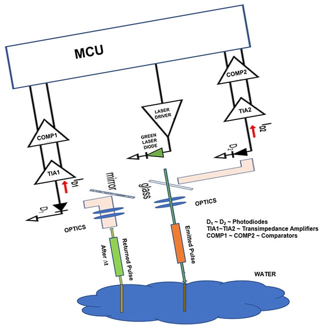
A LiDAR system measures the time-of-flight (ToF) of an optical digital pulse train signal. The electronics capture the moment the signal departs and then waits for the signal to bounce off an object and return. The LiDAR system looks for signal edges using a photodetector and a transimpedance amplifier (TIA).
A typical long-distance LiDAR design emits IR light at wavelengths of 1,064 nanometers (nm) to a maximum distance of 250 meters (m) and clocks the reflection time to determine the distance and object contours. This works well for land-based topographic mapping.
In a typical bathymetric implementation, a slow-flying airplane (or drone) actually has two LiDAR systems in the under-wing pods. One has an infrared (IR) emitter for classic topographic measurements; the other has a green emitter, which begs the question, “Why?”
It turns out that light at a shorter wavelength has better water surface penetration; water quickly absorbs IR light at 1,064 nm. For green LiDAR, the wavelength of 532 nm with a pulse rate of 500 Hz excels at providing water depth data. Using a green LED light source, water penetration will reach a depth of 30 m when the water is clear (Figure 1).
 Figure 1: This bathymeter design uses a LiDAR circuit with a green LED set at a 10° angle to accommodate refraction and penetrate the water surface to a depth of 30 m. (Image source: Bonnie Baker)
The bathymeter photo sensing circuitry shown in Figure 1 uses Analog Devices’ AD8652ARZ, a 50 megahertz (MHz), precision, low-distortion, low-noise CMOS amplifier. The bandwidth of the AD8652ARZ is well within the requirements of this circuit, and it has a low-noise specification of 5 nanovolts per root Hertz (nV/√Hz).
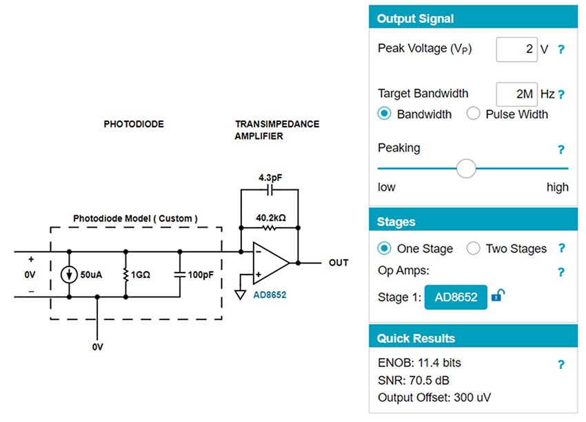
The Analog Devices Photodiode Circuit Design Wizard tool helps with the design of the LiDAR’s transimpedance amplifier (TIA) circuit (Figure 2).
 Figure 2: The Analog Devices’ Photodiode Circuit Design Wizard provides the appropriate circuit for the TIA, and assists in the selection of the photodetector and external feedback resistor and capacitor. (Image source: Analog Devices Photodiode Circuit Design Wizard)
The tool provides a flexible interface to easily produce this circuit. The specifications chosen targeted a bandwidth of 2 MHz, providing ample playroom for the pulses generated by the circuit.
Conclusion
While LiDAR systems with an IR emitter are good for topology measurements, IR is incapable of penetrating water. Enter the green emitting LiDAR solution. The green emitter’s wavelength allows it to handily penetrate calm, clear water up to 30 m.
As shown, using Analog Devices’ AD8655 amplifier and the company’s Photodiode Circuit Design Wizard, designers can get started on creating a water-penetrating LiDAR bathymetric system.
Recommended Reading
An Understanding of How LiDAR Works Shows the Importance of Careful TIA and Comparator Selection

Have questions or comments? Continue the conversation on TechForum, DigiKey's online community and technical resource.
Visit TechForum


