Use a Kit to Develop GNSS-based Precision Positioning Applications Quickly
The use of Global Navigation Satellite Systems (GNSS) has become routine for basic navigation. Still, emerging applications depend on positioning accuracy well beyond the capability of conventional satellite-based navigation systems. Although you can find GNSS correction methods capable of delivering increasingly precise positioning information, their deployment presents multiple challenges in ensuring the required accuracy, reliability, ease of integration, and robust security.
However, rapid progress is being made to address these issues. Let’s look at a fully integrated all-band high-precision GNSS module, evaluation kit, software, and services from u-blox, designed to help you rapidly deploy positioning systems that require centimeter-level accuracy.
Why diverse applications require positional accuracy beyond basic GNSS
Navigation based on GNSS has become a routine part of personal and commercial transportation applications requiring accuracy within a few meters (m). The availability of correction methods like the Wide Area Augmentation System (WAAS) has further brought positional accuracy down to the 1 to 2 m required for precision approaches in aviation, but that’s still not accurate enough for a broader set of applications.
For example, traditional single-band GNSS modules often lack the required precision, speed, and robustness, making them unsuitable for advanced driver assistance systems (ADAS) and self-driving features that require lane-level accuracy. Similarly, effective solutions for drones or autonomous ground vehicles depend on rapid signal convergence, exceptional accuracy, and protection from interference.
Precision agriculture and heavy equipment applications require centimeter (cm)-level accuracy, especially in remote locations where traditional internet protocol (IP)-based correction services struggle with coverage gaps, inconsistent performance, and high operational expenses.
Likewise, telecommunications infrastructure depends on precise nanosecond (ns)-level timing synchronization, a challenging feat for traditional GNSS modules that often struggle with accuracy and susceptibility to spoofing and interference.
Conventional all-band GNSS solutions can improve accuracy but often introduce complexity, increased power demands, and higher costs. The u-blox ZED-X20P all-band high-precision GNSS module directly addresses these application-specific challenges.
How a comprehensive solution enhances positional accuracy
Designed to provide applications with precise positioning data at the broadest possible coverage, the u-blox ZED-X20P module concurrently captures multiple GNSS bands, including L1 at 1559 to 1610 megahertz (MHz), L2 at 1215 to 1252 MHz, L5 at 1164 to 1210 MHz, L6/E6 at 1260 to 1300 MHz, and L-band at 1520 to 1559 MHz.
The module’s all-band capabilities enable it to support multiple GNSS constellations, including Global Positioning System (GPS), Galileo satellite navigation system, BeiDou Navigation Satellite System (BDS), Satellite-Based Augmentation System (SBAS), Quasi‑Zenith Satellite System (QZSS), and Navigation with Indian Constellation (NavIC). Note that if you really need to limit power consumption, you can configure the module to receive only a subset of GNSS constellations.
For developers, the module is designed to speed system integration and reduce complexity, providing a drop-in solution for high-precision positioning thanks to its highly integrated architecture (Figure 1).
 Figure 1 : The ZED-X20P GNSS module provides comprehensive multi-band and multi-constellation support, integrated security, and fast convergence algorithms, helping developers streamline high-precision GNSS designs. (Image source: u-blox)
The module combines its multi-band radio frequency (RF) front-end with a digital block comprising a processor, a GNSS engine, integrated flash memory, and a dedicated timing engine with configurable time pulse synchronization output. It comes in a compact surface-mount package measuring only 17.0 × 22.0 × 2.4 millimeters (mm), and typically consumes about 55 milliamperes (mA) at 3.0 volts.
While the module’s integrated spectrum analyzer monitors the RF environment for interference, the ZED-X20P also protects against multiple direct threats. Its multi-layered defense includes a root of trust with secure boot and secure storage, jamming and spoofing detection, and support for Galileo Open Service Navigation Message Authentication (OSNMA) (Figure 2). Galileo OSNMA ensures secure end-to-end transmission from Galileo satellites, providing civilian users with authentication for their security-critical GNSS applications.
 Figure 2 : The ZED-X20P GNSS module’s support for Galileo OSNMA ensures secure end-to-end transmission from Galileo satellites, providing civilian users with authentication for their security-critical GNSS applications. (Image source: u-blox)
For precision positioning applications, the module supports both real-time kinematic (RTK) correction with observation space representation (OSR) and precise point positioning real-time kinematic (PPP-RTK) correction with state space representation (SSR).
RTK with OSR correction measurements arrive as Radio Technical Commission for Maritime Services (RTCM) messages transmitted by correction-data providers over the internet using the Network Transport of RTCM via IP (NTRIP) protocol. The module’s RTK mode of operation provides a straightforward solution to relatively short-baseline applications built with either Network RTK (nRTK) or single-station RTK. With nRTK, the module uses RTCM corrections from a Virtual Reference Station (VRS) service provider operating a VRS network. In single-station RTK, the reference station is local, transmitting correction data to the rover receiver.
For example, a robotic mower application can easily use single-station RTK, where one ZED-X20P module serves as the reference station providing corrections to a second ZED-X20P that operates as the rover receiver (Figure 3).
 Figure 3 : Using native support of RTK with OSR, two ZED-X20P modules can quickly be configured to support short-baseline applications such as robotic lawnmowers. (Image source: u-blox)
PPT-RTK with SSR also uses the NTRIP protocol, but rather than delivering specific correction data, this protocol streams satellite-centric models, including orbits, clocks, and signal biases, to the receiver using the Secure Position Augmentation for Real-Time Navigation (SPARTN) format. Using the streamed data, a PPT-RTK with SSR receiver computes local corrections itself using data contained in SPARTN messages transmitted over the mobile internet or through L-band satellite broadcast.
Because this correction protocol combines very low data rates with receiver-computed corrections, it is particularly effective for long-baseline applications with limited communications bandwidth. With its L-band receiver capabilities and native support for SPARTN/SSR, the ZED-X20P module is well-suited for applications such as unmanned aerial vehicles (UAVs), agricultural equipment, and logistics/transport systems, where mobile internet connections might be spotty at best. For acquiring correction information, you can take advantage of the u-blox PointPerfect Flex PPP-RTK correction service, which offers cost-effective usage-based plans supporting SPARTN-format messages transmitted via mobile internet connections or L-band satellite connections.
With access to reliable correction data received over a high-quality antenna such as the u-blox ANN-MB2-00, the ZED-X20P module achieves RTK positioning accuracy of 0.6 cm + 1 part per million and PPP-RTK positioning accuracy of <6 cm with typical convergence times of <7 seconds (s) and <40 s for RTK and PPP-RTK, respectively.
Development resources speed evaluation and integration
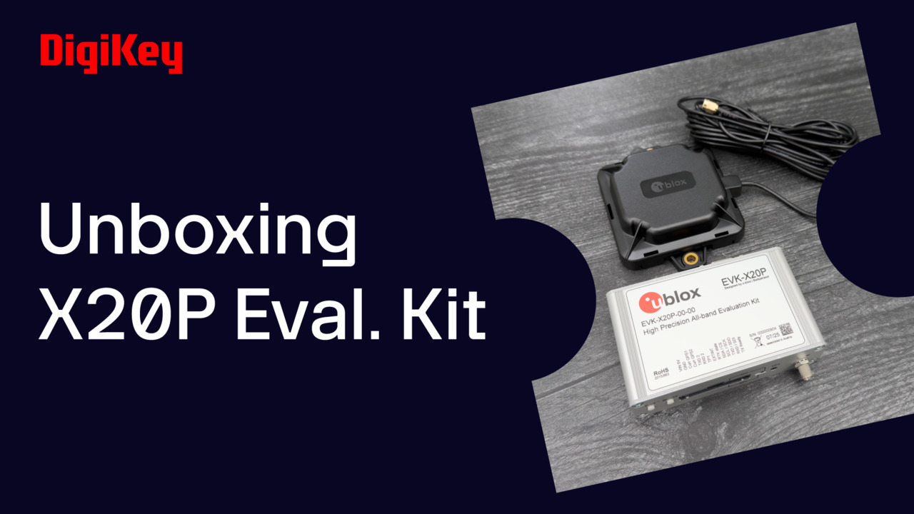
While the ZED-X20P module’s functional capabilities help simplify system integration, the u-blox EVK-X20P-00 evaluation kit (Figure 4) helps you speed module evaluation. Along with cables and an ANN-MB2-00 antenna, the kit includes a board that implements a complete GNSS receiver designed around the ZED-X20P module.
 Figure 4 : The EVK-X20P-00 evaluation kit simplifies GNSS prototyping and integration, providing an easy-to-use hardware and software platform for rapid development. (Image source: u-blox)
To speed evaluation of applications, the u-blox u-center 2 GNSS evaluation software package includes NTRIP server/caster and client tools so you can run a local base and rover configuration with OSR via RTCM or connect the client to PointPerfect Flex for PPP-RTK with SSR.
Conclusion
Many emerging robotics, automotive, agricultural, logistics, and timing applications need centimeter‑class positioning data that basic GNSS and uneven IP connectivity can’t reliably provide. A combination of u‑blox solutions, including the ZED‑X20P GNSS module, EVK‑X20P evaluation kit, u‑center 2 software, and PointPerfect Flex GNSS correction service, offers a quick path to deployment of position- and time-sensitive applications.
About this author

Stephen Evanczuk has more than 20 years of experience writing for and about the electronics industry on a wide range of topics including hardware, software, systems, and applications including the IoT. He received his Ph.D. in neuroscience on neuronal networks and worked in the aerospace industry on massively distributed secure systems and algorithm acceleration methods. Currently, when he's not writing articles on technology and engineering, he's working on applications of deep learning to recognition and recommendation systems.

Have questions or comments? Continue the conversation on TechForum, DigiKey's online community and technical resource.
Visit TechForumMore Blogs from this Author